Earth Observation
Image Credit: ISRO
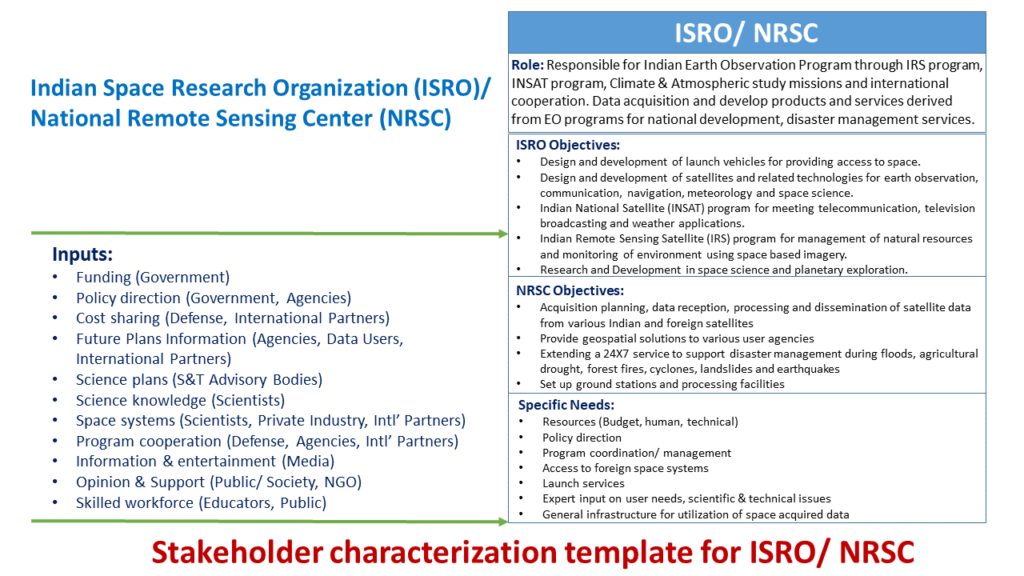
Earth Observation through satellites has been a core objective of the Indian Space Program for harnessing the space technology for national development.
Indian Remote Sensing (IRS) Satellites system supports the Indian national economy in the areas of agriculture, water resources, forestry, ecology, geology, watersheds, marine fisheries and coastal management, and advanced research in Earth Sciences. The IRS satellites system began in 1988 with the launch of IRS-1A satellite. IRS series of satellites are designed and built by the ISRO Satellite Center based in Bengaluru while the ISRO Space Application Center in Ahmedabad fabricates the remote sensing payloads and cameras.
WiFS provided vegetation Index mapping (28 Dec 1995 – 21 Sep 2007). [Credit: ISRO]
The IRS satellites data has been used for a variety of national applications such as ground water targeting utilizing hydrogeomorphology mapping, forest density mapping, flood affected area mapping and crop acreage and production estimation for a variety of crops such as wheat, paddy, groundnut and cotton.
The meteorological payloads of the Indian National Satellites (INSAT) system provide for weather and natural disaster management support. As part of the EO program, ISRO has developed and launched several satellites to monitor the oceans that cover over 70% of Earth’s surface, such as the currently operational Oceansat-2 satellite with three payloads.
The National Remote Sensing Center (NRSC) based in Hyderabad is responsible for the acquisition, processing and supply of data to the various national programs that utilize the remote-sensing data for optimal use of country’s national resources and water management.
ISRO/ NRSC – Disaster Management Support
The Decision Support Center (DSC) for Disaster Management utilizes National Database for Emergency Management (NDEM), a national repository of GIS records for near real-time monitoring & mapping of disaster areas for assisting State/ Central authorities for damage assessment and coordinating relief efforts.
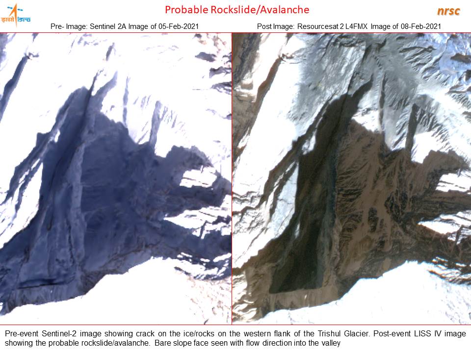
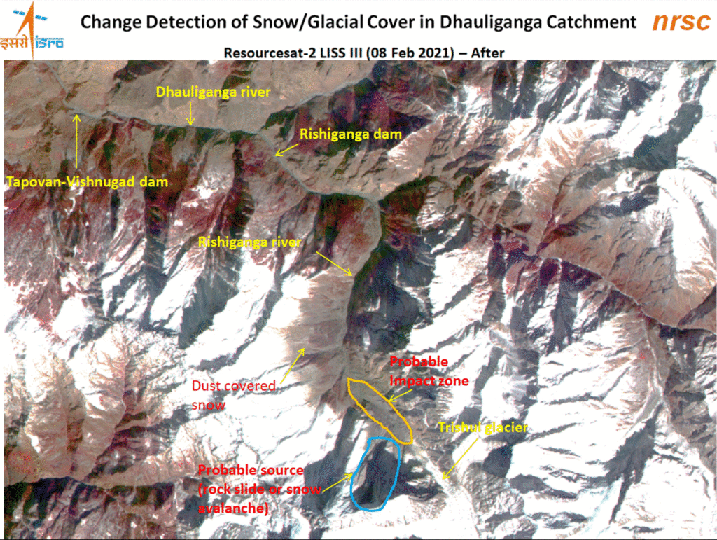
On February 7th, 2021, a major snow/ glacial avalanche took place near the Raini village in the State of Uttarakhand (Trishul Glacier in the Himalayas) causing flash floods in the Rishi Ganga and Dhauli Ganga catchment areas causing loss of lives and damage to Power Plants located at Raini and Tapovan.

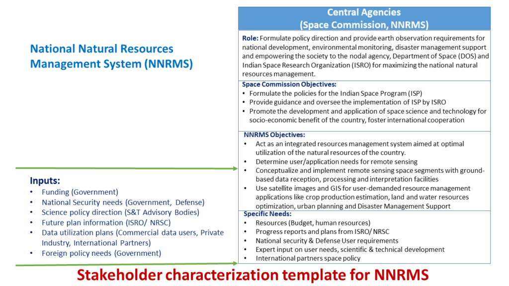
The National Natural Resources Management System (NNRMS), an autonomous organization under the aegis of the Indian Department of Space (DOS) oversees interagency coordination among the various national departments that utilize the EO data and addresses underutilization and inadequacies in regional and district level ground facilities.
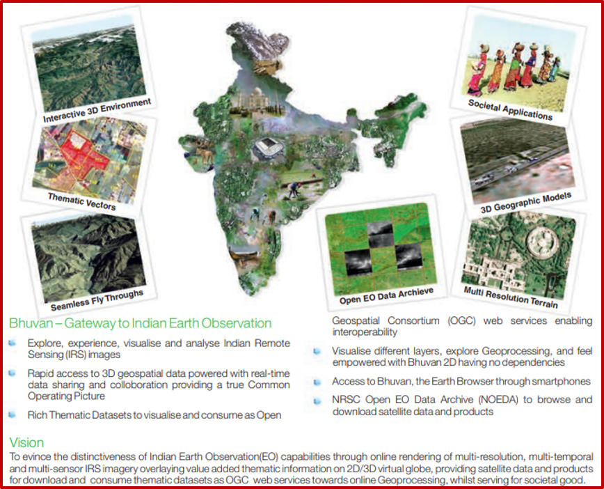
BHUVAN – Indian Geo Portal for Earth Observation Data & Visualization
Bhuvan (means Earth in Sanskrit language) is the Indian Geo-portal for Earth Observation data and visualization to aid in the monitoring of national development initiatives and inform decision-makers based on multi-spectral and multi-temporal data from Indian remote sensing satellites.
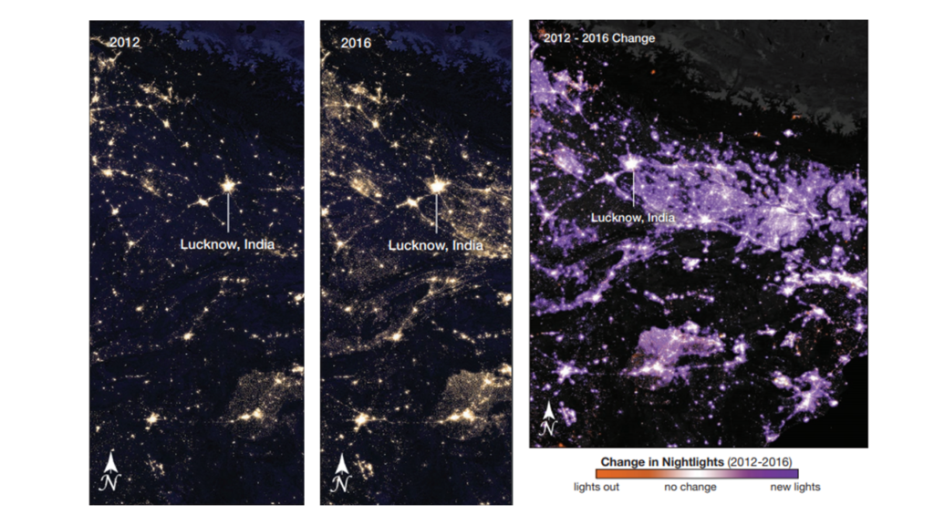
Urban Development in India is growing at an accelerating pace and the urban population is expected to increase from 34.5% in 2019 to about 40% in 2030. ISRO’s constellation of remote sensing satellites provide fundamental data for urban planners and policymakers in monitoring the dynamics of land use, changes in surrounding spacial environment and the effects of federal initiatives such as the federal government electrification program launched in July 2015.
Himalayan Cryosphere, consisting of snow, glaciers, ice sheets, ice shelves and frozen ice is called the third pole due to the large extent of snow and ice cover outside the polar regions. For India and other countries in the region, mountain water resources are important and snow water equivalent (SWE) is a common snowpack measurement used to characterize snow cover.
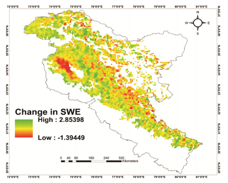
SWE is a direct function of snow depth and snow density and represents the amount of water stored within a snowpack. ISRO’s SCATSAT-1 satellite with Ku-band scatterometer provides high-resolution (~ 2.2 km) brightness temperature and backscatter data over the Antarctica and the Himalayan region.
Future EO Missions:
NISAR – A Joint NASA-ISRO Mission to study Natural Hazards and Climate Change

The NASA-ISRO Synthetic Aperture Radar (NISAR) satellite will provide all-weather, day/night imaging of nearly the entire land and ice masses of the Earth repeated 4-6 times per month. NISAR’s orbiting radars will image at resolutions of 5-10 meters to
identify and track subtle movement of the Earth’s land and its sea ice, NISAR will be the first satellite mission to use two different radar frequencies (L-band and S-band) to measure changes in our planet’s surface less than a centimeter across.
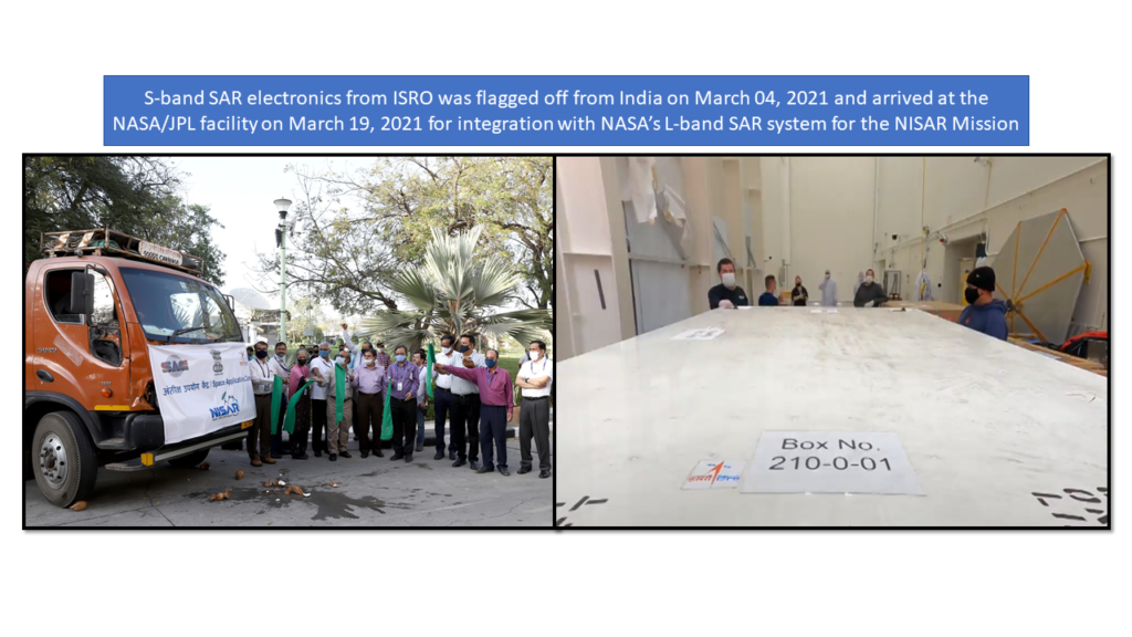
NASA contributions include the L-band SAR instrument, including the 12-m diameter deployable mesh reflector and 9-m deployable boom and the entire octagonal instrument structure. In addition, NASA is providing a high capacity solid-state recorder (approximately 9 Tbits at end of life), GPS, 3.5 Gbps Ka-band telecom system, and an engineering payload to coordinate command and data handling with the ISRO spacecraft control systems. ISRO is providing the spacecraft and launch vehicle, as well as the S-band SAR electronics to be mounted on the instrument structure.
The NISAR mission is planned to be launched in 2022 by an Indian GSLV Rocket.
TRISHNA – A Joint CNES-ISRO Mission to monitor Earth Surface Temperature
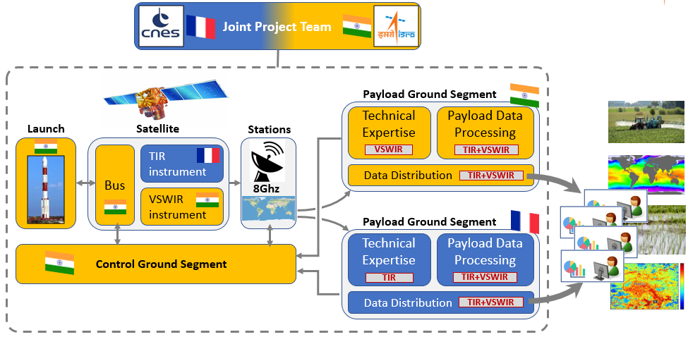
Thermal InfraRed Imaging Satellite for High-resolution Natural resource Assessment (TRISHNA) consists of both a thermal infrared instrument (CNES) and a visible and short-wave infrared instrument (ISRO), that will scan the entire earth surface every 3 days for measuring Land Surface Temperature (LST) and Sea Surface Temperature (SST) capable of observing each point on the earth at least three times per 8 days cycle from an altitude of 761 km above the Earth.
TRISHNA satellite is planned to be launched by an Indian PSLV Rocket in 2025.